22 May Sydney Land Rezoning Explained
Updated February 27, 2025
New South Wales is launching its biggest housing reform in decades with the new Low and Mid-Rise Housing Policy. This major change will override local council planning rules to increase housing development across the state. While the government hopes to speed up approvals and create more homes, there are questions about whether public transportation and other infrastructure can handle the population growth. The government recognizes that bold action is needed to address housing affordability, but urban planners and community groups worry about implementation issues. The challenge will be balancing more housing with maintaining liveable communities that have adequate services.
NSW Low- and Mid-Rise Housing Policy Update
The NSW State Government has recently released their Low- and Mid-Rise Housing Policy (LMR Policy), introducing significant changes to planning controls for properties within 800m of well-located shops and transport hubs.
Key Exclusions
It’s important to note that the following areas are excluded from the LMR Policy:
- Bushfire-prone land
- Flood-prone land
- Coastal wetland or coastal vulnerability areas
- Land within Australia Noise Exposure Forecast or Australian Noise Exposure Concept contour of 20 or greater
Check Your Property
To determine how your property is classified under the new Low to Mid-Rise Housing Policy, you can use this helpful online interactive map. Simply type in an address to see its classification status.
Key Changes and Development Opportunities Under NSW LMR Policy
Dual Occupancies (2 Dwellings on One Lot)
- Now permitted in R2 zones (previously restricted)
- Applies statewide, not just within designated low and mid-rise housing areas
- New non-discretionary development standards for R1, R2, R3, and R4 zones:
- 1. Minimum lot size: 450 m²
- 2. Minimum lot width: 12 m
- 3. Maximum floor space ratio: 0.65:1
- 4. Maximum height: 9.5 m
- 5. Car parking: 1 space per dwelling
- 6. Subdivision (R1, R2, R3 only): 225 m² per lot / 6 m width per lot
Multi-Dwelling Housing (3+ Dwellings on One Lot)
- Now permitted in R2 zones (previously restricted)
- Already permitted in R1 and R3 zones under the Standard Instrument
- New non-discretionary development standards for R1, R2, R3, and R4 zones:
- 1. Minimum lot size: 600 m²
- 2. Minimum lot width: 12 m
- 3. Maximum floor space ratio: 0.7:1
- 4. Maximum height: 9.5 m
- 5. Car parking: 1 space per dwelling
Multi-Dwelling Housing (Terraces) – 3+ Terraces on One Lot
- Now permitted in R2 zones (previously restricted)
- Already permitted in R1 and R3 zones under the Standard Instrument
- New non-discretionary development standards for R1, R2, R3, and R4 zones:
- 1. Minimum lot size: 500 m²
- 2. Minimum lot width: 18 m
- 3. Maximum floor space ratio: 0.7:1
- 4. Maximum height: 9.5 m
- 5. Car parking: 0.5 space per dwelling
- 6. Subdivision (R1, R2, R3 only): 165 m² per lot / 6 m width per lot
Residential Flat Buildings (3+ Apartments in a 2+ Storey Building)
- Now permitted in R2 and R3 zones (previously restricted)
- Already permitted in R1 and R4 zones under the Standard Instrument
- New non-discretionary development standards:
In R1 and R2 zones:
- Minimum lot size: 500 m²
- Minimum lot width: 12 m
- Maximum floor space ratio: 0.8:1
- Maximum height: 9.5 m
- Car parking: 0.5 space per dwelling
In R3 and R4 zones:
0–400 m from station/town centre:
- Floor space ratio: max 2.2:1
- Height: max 22 m (6 storeys)
- No minimum lot size or width (LEP provisions removed)
400–800 m from station/town centre:
- Floor space ratio: max 1.5:1
- Height: max 17.5 m (4 storeys)
- No minimum lot size or width (LEP provisions removed)
LEP Override Provision
The policy states that this can override a local Environmental Plan (LEP) if it complies with the standards listed above:
“A non-discretionary development standard, also known as a non-refusal standard, provides consistent development assessment guidelines for matters like building heights, floor space ratio or lot size. A non-discretionary standard can overrule a local environmental plan (LEP) or development control plan (DCP) standard. If the proposed development complies with the non-discretionary standard, a consent authority cannot refuse the application because it does not meet the LEP or DCP standard.”
This information comes directly from NSW State Government’s Planning Portal. For more detailed information about the policy, visit the NSW Planning Portal directly: 🔗 Low and Mid-Rise Housing Policy
Published May 22, 2024:
Rezoning across Sydney and NSW has been a hot topic since news of the NSW’s government’s land rezoning plans became public. In a bid to tackle the growing housing and affordable living crisis in Sydney, the government aims to tackle the problem in two phases under the Transport Oriented Development (“TOD”) program which we outline below.
In parallel with this, additional proposed housing reforms are set to change the face of Sydney’s suburbs. These, in combination with the TOD reforms, will help to achieve the desired “infill” of housing around existing community infrastructure. The initial proposals will encompass properties within 400m and 800m radius of stations, town centres and well-located areas.
The proposed housing reforms seek to:
- Allow dual occupancies (two separate homes on a single lot), such as duplexes, in all R2 low density residential zones across all of NSW.
- Allow terraces, townhouses and 2 storey apartment blocks near train stations and key town centres in R2 low density residential zones across the Greater Sydney region, Hunter, Central Coast and Illawarra Shoalhaven (Six Cities Region).
- Allow mid-rise apartment blocks near train stations and key town centres in R3 medium density zones across the Six Cities Region.
- Introduce new planning controls, such as floor space and height allowances, that encourage low- and mid-rise housing in well-located areas.
The planned proposals are currently on public exhibition. Final determinations will be made and come into effect at the end of June 2024.
Transport Oriented Development (“TOD”)
TOD Part One:
In this phase, the aim is to rezone eight areas within 1,200m of transport hubs by November 2024. The result of this will see 47,800 homes built over the next 15 years. These suburbs are part of the TOD – Accelerated Precincts.
The 8 priority high-growth areas near transport hubs in greater Sydney for accelerated rezoning are:
- Bankstown
- Bays West
- Bella Vista
- Crows Nest
- Homebush
- Hornsby
- Kellyville
- Macquarie Park
TOD Part Two:
The second phase of the program commenced on the 13th of May 2024 with the amendment to the State Environmental Planning Policy (SEPP).
The new planning controls will be implemented within 400m of 37 train stations across NSW to deliver more affordable, well-designed and well-located homes. Below is a list of the impacted Sydney stations. The finalisation for some stations has been deferred to give those councils time to make appropriate planning changes that either meet or exceed the TOD plan.
| Suburb | Government Area | Finalisation Date |
| Turella | Bayside | Apr-24 |
| Banksia | Bayside | Jul-24 |
| Rockdale | Bayside | Jul-24 |
| Kogarah | Bayside/Georges River | Apr-24 |
| Croydon | Burwood/Inner West | Jan-25 |
| North Strathfield Metro | Canada Bay | Oct-24 |
| Punchbowl | Canterbury | Jun-25 |
| Canterbury | Canterbury Bankstown | Oct-24 |
| Wiley Park | Canterbury Bankstown | Jun-25 |
| Belmore | Canterbury Bankstown | Dec-24 |
| Lakemba | Canterbury Bankstown | Dec-24 |
| Lidcombe | Cumberland | Apr-24 |
| Berala | Cumberland | Oct-24 |
| Ashfield | Inner West | Dec-24 |
| Dulwich Hill | Inner West | Dec-24 |
| Marrickville | Inner West | Dec-24 |
| Gordon | Ku-ring-gai | Apr-24 |
| Killara | Ku-ring-gai | Apr-24 |
| Lindfield | Ku-ring-gai | Apr-24 |
| Roseville | Ku-ring-gai | Apr-24 |
| St Marys Metro | Penrith | Apr-25 |
What are the Sydney Land Rezoning Changes?
The recent changes in the regulations now allow for the construction of residential flat buildings in residential zones R1, R2, R3, R4, and employment zone E1, as well as shop-top housing in employment zones E1 and E2. With council’s consent, residential flat buildings and shop-top housing can now be constructed in areas where it was previously restricted by the council’s local environmental plans.
What Are The New Planning Controls?
The new SEPP plans as outlined by Planning NSW include the following directives to development and planning:
- Permissibility – Allowing residential flat buildings in residential zones and local centre zones, along with shop top housing in local centre and commercial zones.
- Building Height – A 22 metre height for residential flat buildings to maintain design standards, and a maximum building of 24m for buildings containing shop top housing to accommodate commercial ceiling height.
- Floor space ratio (FSR) – A maximum FSR of 2.5:1 has been set. This allows for buildings of up to 6 storeys while providing for good design outcomes in relation to landscaping, building setbacks, privacy and open space.
- Lot size and width – Introduction of a minimum lot width of 21m and no minimum lot size.
- Street frontages – The inclusion of a clause which applies to local centre zones to consider of active street frontages of buildings at the ground floor.
- Heritage – No change to heritage clauses in local environmental plans. Applications involving heritage considerations will continue to be lodged with and assessed by councils. Any new development needs to improve and enhance the heritage values of those locations.
- Affordable Housing – A 2% mandatory affordable housing contribution, delivered onsite and in perpetuity for developments with a minimum Gross Floor Area of 2000sqm. Affordable housing must be managed by a registered community housing provider. The percentage of the affordable housing contribution will be increased over time.
- Apartment design guide (ADG) – The guide will continue to be the principal guiding document for apartment development, including TOD developments.
How The Housing Reforms Impact You:
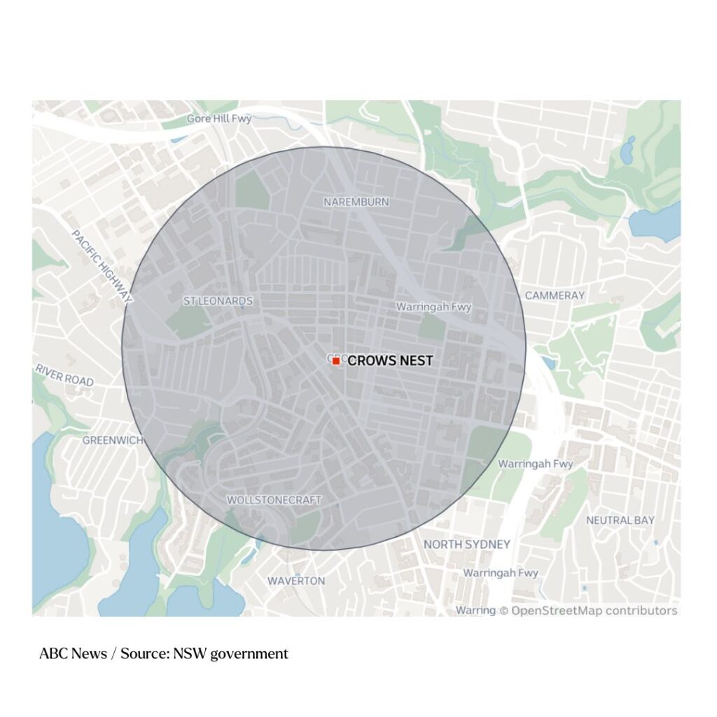
Importantly, it may not only be the identified suburb that is affected. Take the accelerated station of Crows Nest as an example. The 1200m radius extends beyond Crows Nest into the neighbouring suburbs of Naremburn, Cammeray, St Leonards, Wollstonecraft and part of North Sydney. See chart below.

The suburbs of Naremburn, Cammeray, St Leonards, Wollstonecraft and part of North Sydney are also within the new rezoning area of Crows Nest Station.
Hornsby’s 1200m radius also includes part of Waitara, and Homebush’s rezoning includes North Strathfield. The Bays is a planned new station that will utilise undeveloped waterfront land and the 1,200m zone around this station does reach into residential areas in nearby Glebe, Rozelle and Balmain.

How To Check If Sydney’s Land Rezoning Impacts You:
Search the NSW Planning Spatial Viewer to see if your home or business is within 400m of a TOD station.
As Buyers’ Agents we always recommend you do thorough research when it comes to buying property. However it is even more important if you are within these zones or on the fringe of these zones. In some cases it has the potential to add value to a property. For example, if there is a redevelopment opportunity. However, there can be situations where it negatively impacts the value of a property. Buying a property is a significant investment and it’s crucial to avoid mistakes when buying your most valuable asset. Feel free to contact us to discuss how we can help you achieve your property goals.
For further information on rezoning and TOD & SEPP visit the NSW Planning website.
For further information on the planning reforms running parallel to the TOD reforms for mid to low-density housing click here.


